Fairy Meadows:
Nestled amidst the majestic peaks of the Pakistani Himalayas, Fairy Meadows is a place of unparalleled beauty and enchantment. This pristine alpine meadow, aptly named for its ethereal charm, offers a mesmerizing escape into a world of breathtaking landscapes and natural wonders.
Hunza:
Hunza, nestled in the mighty Karakoram Range of Pakistan, is a land of unparalleled beauty that captivates the hearts of all who venture into its breathtaking landscapes. Its awe-inspiring mountains, crystal-clear rivers, and lush green valleys combine to create a paradise on Earth. The beauty of Hunza lies not only in its natural wonders but also in its rich cultural heritage and warm-hearted people.
Rush Lake Trek:
The Rush Lake Trek offers an extraordinary journey through the breathtaking landscapes of the Pakistani Karakoram Range, revealing a beauty that is both awe-inspiring and humbling. This trek takes adventurers to the mesmerizing Rush Lake, the highest alpine lake in Pakistan, nestled among towering peaks and surrounded by an aura of tranquility and grandeur.
Islamabad International Airport (Google Map)https://goo.gl/maps/XLSCs8vW7NpdQp8t7
3 Hours Before Flight Time
Arrive in Islamabad. A representative of Karakorum Adventures will meet you outside the customs and immigration area at the airport. This representative will answer questions, brief you on the immediate arrangements, and escort you to the hotel in Islamabad. Discover the twin cities of Islamabad and Rawalpindi. Rawalpindi is an old British -era settlement and Islamabad is the capital city and administrative centre built sometime after the partition of India in elevation in 1947. The cities are Located at about 1,500 feet in elevation in the hot and steamy plains of Pakistan’s upper Punjab. You may wish to explore Rawalpindi by wandering among its many and varied bazaars, or visit the imposing Shah Fasil Mosque superbly situated at the foot of the Margalla Hills. This mosque is one of the largest in the world, with room for 15,000 worshippers inside and 85,000 in the courtyard. This day we will attend a trek briefing at the Alpine club of Pakistan.
Breakfast included.Overnight in Hotel.
KKH is the highest paved international road in the world. It connects China and Pakistan across the Karakoram mountain range, through the Khunjerab Pass, at an elevation of 4,733 m/15,397 ft. It connects China’s Xinjiang region with Pakistan’s Gilgit-Baltistan and Khyber Pakhtunkhwa regions and also serves as a popular tourist attraction. Due to its high elevation and the difficult conditions in which it was constructed, it is also referred to as the “Eighth Wonder of the World. The Karakoram Highway, also known as the Friendship Highway in China, was built by the governments of Pakistan and China, it was started in 1959 and was completed in 1979 (open to the public since 1986) about 810 Pakistanis and about 200 Chinese workers lost their lives, mostly in landslides and falls, while building the highway. The route of the KKH traces one of the many paths of the ancient Silk Road.
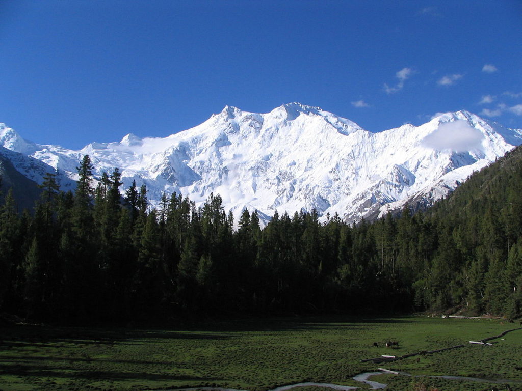
Morning after breakfast we will visit the the cpan rock carvings and drive (2 hours) to Raikot Bridge. From here, drive one hour by 4 wheel jeeps to Tato village through the narrow gorge of Raikot. After Tato, 2 hours trek on the pony trails through the thick covered pine forest leads to fairy meadows.
Meals and overnight in huts.
Excursion towards Nanga Parbat base camp. (north face of Nanga Parbat 4000m). An easy and gentle walk through the green meadows covered with thick pine and birch forests. After beyal we cross ganalo glacier and then we walk on lush green grassy meadows. Visit alfred drexel monument and explore the area. After lunch trek back to Fairy meadows. (7 hours),
Overnight in huts.
Morning drive to Minapin village in Nagar valley, through the scenic mountain villages and a brief stop at the Rakaposhi viewpoint to have the magnificent view of the Rakaposhi, continue drive to Minapin
Overnight at Rest house
From here we start our first day of trek, a gradual steep walk on the pony trail through the green meadows and high altitude pine trees to this green camp site. Meals and overnight in tents.
Overnight at Camp
An easy walk along the minapin glacier takes you through the green slopes of the meadows and a very spectacular view from the green flat ground on the banks of minapin glacier. Afternoon explore the area. Meals and overnight in tents..
Overnight at Camp
Trek Back to Minapin and after some refreshment we drive to hunza .Hunza Valley is a mountainous valley, situated north/west of the Hunza River, at an elevation of around 2,500 metres. The territory of Hunza is about 7,900 square kilometres (3,100 sq mi). Aliabad is the main town, while Baltit and Altit are popular tourist destination because of the spectacular scenery of the surrounding mountains. The people are cheerful, friendly, fair-skinned and blue or green eyes. Almost all speak Burushaski and in upper Hunza they speak Wakhi. The miracle of the Hunzakuts longevity, supposedly resulting from their mostly vegetarian diet of cereals and fruits From Hunza Valley. Panoramic views of Rakaposhi 7788 m, Diran Peak 7266 m, Spantik Peak 7027 m,Ultar 7388 Lady Finger 6000m.
Overnight At Hotel in Hunza
After breakfast you will visit Altit and Baltit Forts and at evening you will visit Duikar to see the sunset.
Baltit fort, one of the high valleys between China and Indian subcontinent. Facing Rakaposhi Peak, one of the highest mountain peaks in the world, Baltit Fort is poised majestically above Karimabad, the present day capital of Hunza (Baltit was the capital of the old state of Hunza, and is now included in the Karimabad settlement area). Located on the rocky upper level of the Hunza hill and surrounded by Ultar Bar to the east, the Hyderabad Har to the west, Mount Ultar and its subsidiary range to the north, the Fort offers breathtaking views of the magnificent high mountains as well as a bird’s eye view of the villages in the valley. Baltit Fort has great historical, cultural and symbolic value to the local community. Historically, it was the seat of the Mirs of Hunza, a family that ruled the region for centuries. Culturally, with some buildings dating back to 12th century, it is a record of the architectural evolution of the area. The main building is an impressive stone structure with intricately detailed timber features. Its architecture is a significant example of Pakistan’s diverse heritage, reflecting distinct Tibetan influence as seen by the presence of a Tibetan ‘sky-light’ in the roof. Socially, the fort and the surrounding settlements are valuable symbols and reminders of man’s creativity and persistence in overcoming an unfavorable and hostile natural environment for the purpose of survival.
Altit Fort: It has been built on a sheer rock-cliff that falls 300 meters (1000 feet) into the Hunza River, and is much older than the Baltit Fort. View of Altit fort, with the central town to the right and below the fort. The extreme gullies, sharp drop-off, and location high above the river made this settlement highly defensible and an older settlement than many in the central valley. The majestic historical Altit fort is center of attraction due to its architectural design and strategic location. Altit is the birthplace of the Hunza Kingdom and Altit fort is the first fort of the region. The fort has been constructed in six different stages by using various natural levels of the rock. The construction has been made right on the edge of a sheer rock cliff that drops 1000 feet straight down to the Hunza River. In the beginning it was built as a palace, soon after the addition of the watch tower a defensive architectural element it transformed to a fort. There is great possibility that different stages of the fort have been constructed during different times because the actual age of the fort is said to be more than 800 years. This fort is said to be around 50-100 years older than Baltit Fort.
Overnight at hotel.
Today is free day in hunza you can take rest and prepare yourself for upcoming rush lake trek or optional excursion to khunjerab pass pak china border.
The Khunjerab Pass is the highest paved international border crossing in the world and the highest point on the Karakoram Highway. The roadway across the pass was completed in 1982, and has superseded the unpaved Mintaka and Kilik Passes as the primary passage across the Karakoram Range. On the Pakistani side, the pass is 42 km (26 mi) from the National Park station and checkpoint in Dih, 75 km (47 mi) from the customs and immigration post in Sost, 270 km (170 mi) from Gilgit, and 870 km (540 mi) from Islamabad. On the Chinese side, the pass is the southwest terminus of China National Highway 314 (G314) and is 130 km (81 mi) from Tashkurgan, 420 km (260 mi) from Kashgar and some 1,890 km (1,170 mi) from Urumqi. The Chinese port of entry is located 3.5 km (2.2 mi) along the road from the pass in Tashkurgan County.After spending some time on the pak china border we drive return to hunza .
Overnight at hotel.
Early in the morning we drive to hopper and then trek to Barpiu Giramcamp It will be a hot walk so keep your water bottles full. First we will cross Hoper glacier, then continue track along the lateral moraine for about an hour and arrive at Shiskin. Then we will climb a stony and hot gully to reach Barpu glacier, in one hour we will cross the Barpu glacier,the crossing is again, bit steep.
Night at Camp
Day 12 Trek to Chidin Harai, Camp.
After an early breakfast, we walk to the Chidin Harai (4 to 5 hours).
This steep 1140m climb. Chidin Harai enjoys late afternoon light and is a perfect camp from which to enjoy sunset and sunrise against the backdrop of vast peaks. This wall of 7000m peaks includes: Lupgar SAR (7728m), Mulungutti SAR (7025m), and Disteghil SAR (7885m). Over night at camp . Camp
Overnight at Camp
Rush Lake (4,700 m 15,400 ft): Camp, trek. In about 2 hours of walking we will arrive at one of the most beautiful place in the Hunza valley having awesome views of the Karakorum. If we climb a nearby hilltop, we can see K2 along with the other high peaks of the Karakorum from there. Camp
Overnight in Camp
This day is reserved to regain the lost energy on the trek and enjoy the great panorama.
Night at camp
Phay Phary (3,500 m 11,480 ft): Camp, trek. An epic descent day! We will come down about 1,200 m. in 4 hours or so. The descent is on grassy slopes.
Night at Camp
After breakfast at camps we will start our trek, first we will cross Miar glacier with magnificent views of Miar Peak (6824 meter).
Night at Camp
Today we will walk on lush green meadows between summer cattle sheds having full head on view ofthe Ultar peaks. After 3 hour walk and crossing Hoper glacier we will reach Hoper village and from there we will drive to town of Karimabad.
Overnight in Hotel
Drive along the bank of Hunza river on Karakoram Highway, enjoying fascinating views of Karakoram Peaks from a different angle. We might stop at Gilgit town for lunch. Arrive Chilas on the bank of Indus river, overnight at hotel Chilas.(235 KM, 7 hrs drive).
Night stay at Shangrila Midway House. Chilas.
Full day drive on Karakoram Highway to Islamabad. We start early in the morning, to cover the 13 hours long drive. Short stay in Besham for lunch, by evening we shall reach Islamabad.
Night at Hotel
You will be transferred to the airport for international departure. Our representative will say Khuda Hafiz “May God be your protector” here.