Broad Peak is named for the immense bulk of its peak. It has a strong presence in its environs. Its local name is ‘Falchan Kangri’. Upon arriving in Islamabad, we then fly to a mountain town called Skardu or if the weather is inclement we travel by road through the Indus gorge to Skardu and the parting point from civilization. Jeeps take us to the road end at Askole, the last village in the valley. Askole is the beginning of the trek to base camp and each night we camp out as we travel up the valley with our Balti porters providing entertainment and colour to the otherwise stark and barren countryside.
Our next camp is Paiyu, the last campsite before the beginning of the Baltoro glacier. Then the route to Broad Peak follows the opposite (true left) side of the Baltoro, passing spectacular views of the Trango group, trekking for a further 6 days to reach the base camp. The route involves climbing through a rock gully to Camp I (6000m) then by following a large snow face we reach CII at around 6400m. A final camp is placed at 7400m from where we make the summit bid. The climbing will not be extremely steep but the remoteness of the setting will make this an especially rewarding experience. Whether this is your first 8000m peak or your third, the nature of climbing in this region will have it’s own unique flavor.
Islamabad International Airport, pakistan(GoogleMap)
3 Hours Before Flight Time
Arrive in Islamabad. A representative of Karakorum Explorers will meet you outside the customs and immigration area at the airport. This representative will answer questions, brief you on the immediate arrangements, and escort you to the hotel in Islamabad. Discover the twin cities of Islamabad and Rawalpindi. Rawalpindi is an old British -era settlement and Islamabad is the capital city and administrative centre built some time after the partition of India in elevation in 1947. The cities are Located at about 1,500 feet in elevation in the hot and steamy plains of Pakistan’s upper Punjab. You may wish to explore Rawalpindi by wandering among its many and varied bazaars, or visit the imposing Shah Faisal Mosque superbly situated at the foot of the Margalla Hills. This mosque is one of the largest in the world, with room for 15,000 worshippers inside and 85,000 in the courtyard. This day we will attend a trek briefing at the Alpine club of Pakistan.
Overnight Hotel. Breakfast included.
A thin ribbon of asphalt strikes north from near Islamabad and leaves the modern capital and the dusty Punjab plains far behind. As it weaves through sparse green hills, the first wrinkles of mountain-building in this geological ‘collision zone’, this unassuming road gives little hint as to what lies ahead. This is the high road to China, the Karakoram Highway (KKH), which was blasted and bulldozed through an intractable landscape of raging rivers, deep ravines and precipitous peaks in the 1960s and ’70s. It is a 1200km marvel of engineering and a symbolic collaboration between Pakistan and China. It is also a magnet for adventure-seekers.
Along the KKH you will encounter ancient towns of Taxila, Hassanabdal, Abbottabad, Besham, Dassu. It’s a long drive(13 hours) so the journey will start early from Islamabad.
Overnight at hotel in Chilas. Full Board, all meals included.
Thirty-eight kilometres south of Gilgit, the road to Skardu (170km) leaves the KKH and crosses a bridge and a spit of rock into the upper Indus Valley. Ten minutes from the bridge is a perfect panorama of the entire Nanga Parbat massif, and shortly afterwards there’s a brief view ahead to Rakaposhi south face. Fifteen minutes later the Indus is at its northern-most point. Another 15 minutes on (27km from the KKH) is the fuel stop of Sassi, a green island in a sea of crumbling rocks.
With its size, desolation and the non stop foaming fury of the Indus, the gorge from here south is simply awesome. Where there are no bridges, people still cross by pulling themselves hand over hand in a sphincter-puckering contraption consisting of a platform hung from a pulley on a single cable, often hundreds of metres above the river. At the truck stop of Thangus, 53 km from the KKH, look across the river for miners scraping out a living by burrowing into the mountain’s quartz veins for crystals.
Another 7km further on is a popular travellers’ stop at the basic Midway Hotel and, across the road, PTDC Astak, about 89 km from Skardu. About 31/2 hours from the KKH (21/2 hours from Skardu) is the regional centre Thowar. Across the river is Mendi, capital of the ancient Rondu kingdom. Below Basho the canyon opens into the vast Skardu Valley, and an hour later you’re in Skardu bazaar.
In good weather the 170km trip takes six to seven hours, with at least two police checkpoints. In rainy weather (eg summer storms and winter drizzle) multiple slides may block it completely.
Overnight in Hotel. Full Board, all meals included.
The expedition upon arrival in Skardu should see the officer concerned in Tourism Division for arranging meeting with the Liaison Officer and assistance on matters like insurance, purchase of rations and allied matters.
The rest of the day can spend sightseeing in Skardu.
Overnight in Hotel, Full Board, all Meals included.
We have a free day in Skardu if we flown the previous day. We have free time explore the town and visit the historic fort of Skardu situated 40 feet high on the northern hill side of main Skardu city. The fort lock from east and north angles by mighty Indus river, so it possesses tremendous strategically advantage and significant geographical position from military point of view. Therefore it is locally called “Kharpocho” which means Strong Fort. We’ll explore its narrow bazaars and in the afternoon visit Turquoise blue Sadpara Lake by bus or a jeep which is about four miles south of the town.
We will travel by jeep with our crew and supplies along the Shigar and Braldu valleys to Askole. Village in Shigar have changed little in over five hundred years; farms with fields of barley, wheat and vegetables surrounded by stone walls and stands of poplar, willow and apricot trees. The apricot is a very important crop in the north, having a multitude of uses to the Balti and Hunzakut people. Villagers greet us as we pass through on the rugged dirt and stone road that leads to Baltoro. As we approach, the landscapes become desert like and once within the sheer valley of the Braldu, it is necessary to cross the river several times by suspension bridges. At various points the road may have collapsed due to erosion and we will transfer the gear across on foot to a vehicle on the other side. The journey may take anywhere from six to twelve hours, with patience, we will arrive at our first camp of the trek. In Askole the villagers grow their own cereals, vegetables and fruit and own large herds of sheep, goats and dozes.
Overnight in tents. Full Board, all meals included
After considerable organisation of equipment, supplies and porter loads for the journey ahead, we commence trekking towards Jhula. The valley opens out to reveal the Biafo Glacier flowing for more than fifty kilometres from the Hispar La pass to the Braldu. We have our first taste of moraine walking as we cross the snout of the glacier and descend to our lunch spot beside the river at Korofon. We also experience the harsh, stark environment that forms the base of these great mountains. Our route takes us to the confluence of the Braldu and Dumordo Rivers where the infamous flying fox or ‘jola’ is located. It is still there, however a footbridge has now been built making the passage much easier by every perspective. (Consider individual passage of 50 to 70 people with loads, compared with walking straight across a steel bridge!). In past years it was necessary to make a high traverse across a rocky face and descend steeply to the riverside of the Dumordo to gain the flying fox. There is now a safe and pleasant pathway above the river. It is this valley, fed by the Panmah Glacier, which was once a passage between Baltistan and Yarkhand across the West Mustagh Pass (5370m) into China. Once across, we descend beside the river to the Braldu and then follow along its banks to our camp at Jhula.
Overnight in tents. Full Board, all meals.
The trail here is comparatively easy, with occasional exposed scrambles across the rock. The first good water is a thin waterfall after about two hours. There are several campsites called Bardumal along a two-kilometre stretch of sandy river beach scattered with thom bushes and tamarisk. The altitude is about 3,200 metres. Mouse-hares or pika, charming little rabbits with mouse ears, scamper in the rocks. Just beyond Bardumal at Phurblok is the grave of a young porter who died in 1987, where the porters stop to pray. Nearby is a large cave, providing good shelter for porters in bad weather. Water is fetched from side streams.
Opposite Bardumal, the Ching Kang River offers a possible route to the Aling Glacier and Hushe. This route is for fully equipped mountaineers only.
The walk from Bardumal to paiju is undulating, difficult at times, with the first views of dramatic mountains ahead. There is a rest stop by some tamarisk trees beside the stream flowing down from Paiyu Peak. The last hour involves an exposed cliff walk followed by a paddle along the river’s edge.
Paiyu (meaning ‘salt’ in Balti), at about 3,600 metres, was disgustingly polluted in 1990, but many expeditions still chose this camp for their rest day. Empty cans are scattered everywhere, and piles of excrement greet you in every direction. A spring gives rise to a now-polluted stream that runs steeply down through a grove of mature willow and poplar trees. Tent platforms are cut beneath the trees beside the stream.The best bet is to camp higher up, away from shade and water, on a flat shoulder with panoramic views up and down the valley. There are a couple of shepherds’ huts at Paiyu; some of the Askole herds winter here, as it is sheltered and there is less snow here than in the village.The porters use their rest day here to slaughter a goat, driven from Askole, and sing and dance through most of the night.
Overnight in tents. Full Board, all meals included.
After 90 minutes, the path divides at the snout of the Baltoro Glacier. The left branch goes to the base camp of Trango Towers and the Sarpo Lago Pass, which was discovered by Ardito Desio in 1929 and crossed by Eric Shipton and Harold Tilman in 1937. The right branch drops down past some tamarisk trees before climbing up onto the glacier, where the Braldu River roars out of a black hole as from a sluice gate. The glacier stretches up the valley as far as the eye can see—a vast turbulent sea of rocks and gravel two kilometres wide and 62 kilometres long. The porters stop and chant a hymn before crossing the glacier: ‘Oh God, peace be upon the holy Prophet and all his family’—repeated over and over.
You walk across the boulder-strewn ice, up and down great grey slag heaps, climbing steadily for two to three hours on a long diagonal to the other side. Then you follow the southern edge of the glacier across sand and rock for 60 minutes to Liligo or Liliwa (both names are in use), the traditional campsite. From the glacier are spectacular views across to the white, vertically striated pyramid of Paiyu Peak (6,600 metres) and north up the glimmering Trango Glacier to the jagged granite needles and blocks of Trango Towers, one of which, Nameless Tower, soars to 6,239 metres.
From here onwards it takes another 90 minutes to Khobutsi, a lovely walk on a donkey track built by the donkey handlers to carry goods up to supply the army camps at Goro One and Concordia. Khobutsi campsite is the other side of the river flowing from the Liligo Glacier. The river is usually too deep to wade, and the easiest way across is to detour out onto the Baltoro Glacier. There we will find nice campsite at about 4,000 metres, with shade under rocks, a small, clean stream and delicious waterfalls.
Overnight in tents. Full Board, all meals included.
This is a lovely walk mostly along the crest of the lateral moraine, but with one river and a side glacier to cross. There are stunning views across the Baltoro to the serried teeth of Paiyu, Choricho, Uli Biaho, Trango Towers, Cathedral and Biale. Urdukas, one of the most magnificent campsites of the trek, is set at 4,200 metres, about 100 metres above thelateral moraine. The tent platforms here were cut in 1909 by the duke of Abruzzi, and there are natural rock shelters for the porters (urdwaa’kas means ‘a stone with cracks’). Covered in grass and flowers, it faces the panorama of the Baltoro Glacier flowing in front of a continuous wall of granite needles and towers that rise sheer to over 6,500 metres.
Like Paiyu, this site is over-used.
Urdukas was the highest point reached by Colonel Godwin-Austen in 1861. He climbed 600 metres above the camp and saw the gigantic silhouette of K2. The peak was first sighted in 1856 by T G Montgomerie, who noted a cluster of high peaks from a survey point 219 kilometres away and named them Kl, K2, K3, K4 and so on, with K standing for Karakoram. He recognised K2 as the highest and measured it to be 8,619 metres, only three metres more than its new (1988) official height of 8,616 metres, as measured by Professor Ardito Desio of Italy (though most sources still say 8,611 metres). The British usually used local names for mountains: Kl is Masherbrum, and K3, K4, K5 are the Gasherbrum Peaks. K2’s local name is Chogori (meaning ‘big peak’), and it is often known as Mount Godwin Austen (a name never recognised by the Survey of India), yet it is still commonly called K2.
In 1887, Francis Younghusband visited this part of the Baltoro Glacier, arriving from China across the Old (East) Mustagh Pass (5,422 metres), which was a trade route until it was blocked by ice in the middle of the nineteenth century. He walked down to Askole in three days wearing sheepskin slippers. He had no previous mountaineering experience; in fact, this was the first time he had seen a glacier.
From Urdukas on you walk on the glacier all the way and may need to wear gaiters early or late in the season. The first hour is across difficult side crevasses; once out in the centre, the way is smoother and the going easier, but you walk on stones all the way, with only a rare glimpse of white ice. Two to three hours from camp, you are opposite the Yermanendu Glacier, which flows down from the Masherbrum Pass (5,364 metres). This point is known as Goro One (old name Biango). We will camp here, it is worthwhile spending the night here for the clear morning views of Masherbrum, the snowy triangle to the south. At 7,821 metres, it -is the 24th-highest peak in the world, first climbed by the Americans in 1960.
For the next three to four hours to Goro Two, you walk east up the Baltoro Glacier, following the telephone wire from the army headquarters at Goro One straight towards Gasherbrum IV (the name derived from gashay, meaning ‘beautiful’). At 7,929 metres, this is the 17th-highest peak in the world, a sheer-sided pyramid with a flattened top. Over its right shoulder peeps the soaring point of Gasherbrum II (8,035 metres), ranked number 14. Goro Two Camp, at about 4;500 metres, is pitched on the rough, stones and ice in the centre of the glacier, with water from glacial, melt. It is impossible to dig a toilet pit here, and it is’all too easy .to contaminate your drinking supply. The leader should designate a toilet area, west of tamp and make sure the porters use it, too.
Overnight in tents. Full Board, all meals included.
Excitement mounts on the last day. For the next three to four hours to Goro Two, you walk east up the Baltoro Glacier, following the telephone wire from the army headquarters at Goro One straight towards Gasherbrum IV (the name derived from gashay, meaning ‘beautiful’). At 7,929 metres, this is the 17th-highest peak in the world, a sheer-sided pyramid with a flattened top. Over its right shoulder peeps the soaring point of Gasherbrum II (8,035 metres), ranked number 14. Goro Two Camp, at about 4;500 metres, is pitched on the rough, stones and ice in the centre of the glacier, with water from glacial, melt. The walking is slightly easier, and soon after Goro Two you get the famous view north to Mustagh Tower (7,284 metres), seen from here as a gigantic stone axe— apparently sheer sided and unclimbable—at the head of Biango Glacier. It was first climbed from the west by the British in 1956, who made it to the top only five days ahead of the French, who were approaching from the east. Ahead up the Baltoro, you still see Gasherbrum IV, but Gasherbrum II has disappeared. On the southern side, overshadowing Concordia, is the cleft top of Mitre Peak (6,010 metres).
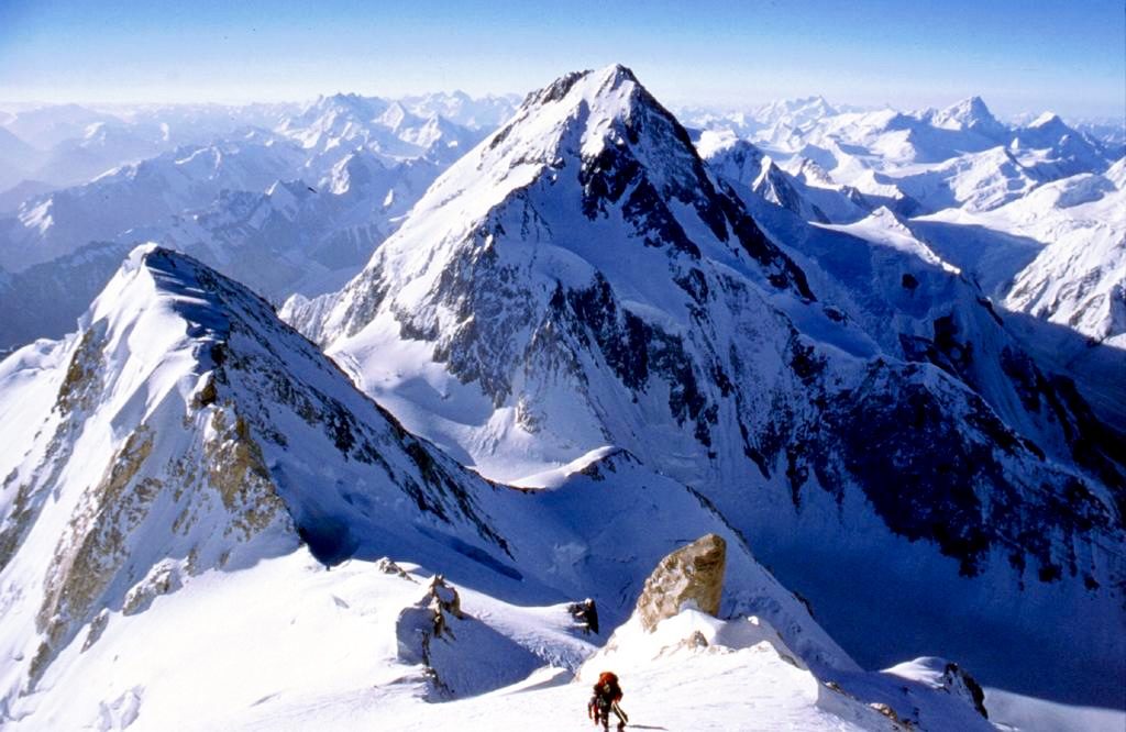
A domed army hut signals your arrival at Concordia, at about 4,700 metres. About ten minutes further on, K2 finally appears on the left, 12 kilometres away. It stands isolated from its neighbours, rising 3,600 metres straight from Godwin Austen Glacier. K2 was first climbed in 1954 by the Italians.
Concordia, the joining of five glaciers so named in 1892 by Martin Conway after the Place de la Concorde in Paris, is an immense sea of ice covered in stones. Glacial fingers reach up to clasp at the surrounding giants. In every direction the views are stunning. To the right of K2, the notched dome of Broad Peak (local name Falcon Congri) crests at 8,060 metres (old measurement 8,051 metres)—a first for Herman Buhl with Kurt Diemberger in 1957. Next is Gasherbrum IV, decorated with a vertical vein of rose-coloured marble, conquered in 1958 by the Italians Walter Bonatti and Carlo Mauri. In the southeast, the shining, glaciated Baltoro Kangri, or Golden Throne, is a giant armchair soaring to 7,312 metres at the end of Abruzzi Glacier. The Swiss Andre Roch and Jimmy Belaieff made the first ascent of the southeast peak of Baltoro Kangri in 1934 and then skied down from about 7,000 metres, creating a world altitude record on skis (see Andre Roch, Karakoram-Himalaya, Sommets de 7000 metres).
To the right of Baltoro Kangri, the smooth white slopes of Kondus are topped by a perfect nipple. Nearer to camp, in the southwest, one of the slender twin peaks of the Mitre (6,025 metres) towers over head. Due west is the view down the Baltoro Glacier to Paiyu Peak- On the north side of the Baltoro Glacier at Concordia is the sharp ice point of Crystal Peak (6,252 metres) glinting like cut glass beside Marble Peak, which occupies the Godwin Austen-Baltoro comer. Coming full circle you see the smooth white wedge of Angel Peak thrusting above the left shoulder of K2. Hidden from view are the 8,068-metre Hidden Peak (Gasherbrum I), which was first climbed by the Americans Andy Kauffman and Pete Schoening in 1958, the 8,035-metre GasherbrumII, which was taken in 1956 by the Austrians, and the 7,952’metre Gasherbrum III, which was conquered by the Polish women’s team led by Wanda Rutkeiwicz in 1975. Within a radius of 15 kilometres are 41 peaks higher than 6,500 metres, many of them unnamed.
Martin Conway was, in 1892, the first person to explore Concordia. He made an attempt on Baltoro Kangri, reaching the top of a spur on the north side, which he called Pioneer Peak.
The first few kilometres from Concordia is across difficult crevasses and glacial rivers. You will save hours by hiring a porter who knows the way to lead you across the snow bridges. Follow a medial moraine north up the Godwin Austen Glacier, with magnificent views back to Chogolisa or Bride Peak (7,668 metres). This is the snowy tomb of Herman Buhl, who fell through a comice in 1957; the peak was finally conquered in 1975 by the Austrians. The duke of Abruzzi had come to within 150 metres of the summit in 1909.
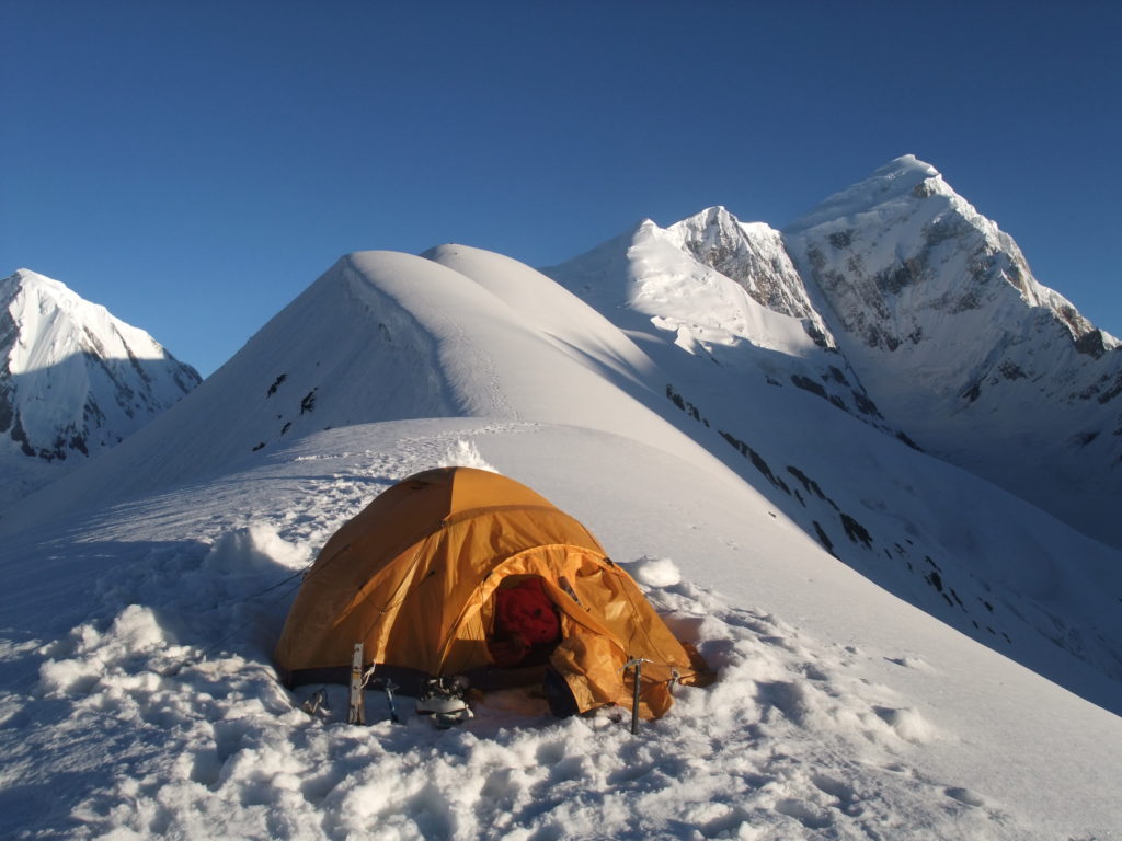
As you approach K2, you look back to Concordia and see the zebra-striped glaciers sweeping round the comer and disappearing down the Baltoro. The striped effect is from the lateral moraines of side glaciers that, as they join the main iceflow, are squeezed into long, parallel ridges of ice bordered by lines of rock and gravel. The lateral moraines having become medial moraines, they sweep dramatically round at Concordia, accentuating the flow of the ice. The easiest walking is on the ice. Stop for lunch at Broad Peak Base Camp. Camp at about 5,000 metres.
The memorials to those killed on K2 are about 20 minutes north of K2 Base Camp, on the rock face above the junction of the Savoia and Godwin Austen glaciers. Walk to the foot of the rock, then scramble up about 30 vertical metres on a rocky path to the memorials, a collection of saucepan lids with the climbers’ names and dates hammered onto them. Return by scrambling down the other side of the ridge to the Savoia Glacier.
By 1990, 55 people had climbed K2, and 25 had died on the mountain. The worst year was 1986, when five separate expeditions were on K2 in early August. Sixteen climbers reached the summit, but 13 died (two British, two American, two French, three Polish, two Austrian, an Italian and a Pakistani), most caught in a storm above 8,000 metres. The first memorial, placed in 1953, was for the American Art Gilkey. Suffering from flebitis in his leg, Gilkey was being dragged down the mountain by Pete Schoening and others, who left him anchored to an ice axe on a steep slope while they prepared the route ahead. When Schoening went back to fetch Gilkey, he was gone, carried off by an avalanche.Overnight in tents. Full Board, all meals included
From day 12 to 34 are reserve for climbing
The first two hours of the trek are difficult as we leave Concordia and traverse the Baltoro Glacier and its crevasses. One of the Vigne Glacier. It’s a comparatively easy and gradual walk over snow and ice, Mighty Chogolisa (25,110 ft.) stand s guard in the south. Overnight at Ali Camp (16,600 ft.), a combination of small rocky platforms between the cliff face and crevasse. We turn in early, as we have a midnight wake-up call for the departure over the Gondogoro La.
Overnight in tents. Full Board, all meals included
We leave camp at about 1:00 a.m.to climb the Gondogoro La (5600m). For the first two hours we walk on the lateral moraine to avoid crevasses. As we get closer to the pass we shift on snow until the base of the pass. The final ascent involves a steep walk on snow and, depending on conditions, the use of fixed ropes as well as crampons and ice axe. The views from the top of the pass are unparalleled, with K2, Broad Peak, Gasherbrum I to IV, Masherbrum, and many other mountains appearing at our level. The descent on the Hushe side is steeper, requiring good balance on the rocks. Camp at Khuispan (4700m.), a lush green meadow with wildflowers covering all around the Camp site.
Overnight in tents. Full Board, all meals included
As we leave Khuispan, we make a long traverse of the Gondogoro Glacier, first encountering small crevasses, then hiking over the soft ice of the Glacier to get to Dalsampa on the other side. The last half hour is a pleasant stroll though wildflowers, with Commanding views of the Gondogoro Glacier, Yermanadu Kangri (7160m) Masherbrum South (7810m), and the Masherbrum La. As we continue, we gradually leave the icy landscapes and descend to the meadow and pastureland at Saistcho (3400m.). Although we’ve left the icy wilds, we still have tremendous views of the mountains, including Defokhar (6540mt.). Continuing along the lateral moraine we descend to Shaitcho, a picturesque campsite nestled amongst tamarisks, wild roses and junipers set beside the river. There are views up to the Charakusa Valley towards K7 (6934m). Tonight there is the chance for song and dance as the porters are relaxed and happy with a successful crossing of the Gondogoro La behind them.
Overnight in tents. Full Board, all meals included
Trek to Hushe (3150m) 4-5 hrs Descend to the Gondogoro River, enjoying spectacular views of K6 (23,881 ft.), K7 (22,744 ft.) and Link Sar (23,094 ft.),. We continue to descend, passing through small summer settlements en route to the green irrigated fields at Hushe. By jeep to Skardu. Meet with jeeps and drive to Skardu, passing through many picturesque villages perched on vertical rocks. This part of Baltistan appears greener and more prosperous than on our drive to Askole. Overnight at Concordia Motel/Mashabrum Hotel, Skardu.
Overnight in Hotel.Full Board, all meals included
We will visit tourism ministry for de-briefing. Rest of the day is for free.
Overnight in Hotel. Full Board, all meals included.
Today, we will start our journey back toward south. Along the way we will stop over at astak PTDC for Lunch and Continue our journey in gorges of Indus to Chilas, our destination for the night. Overnight hotel
Drive to Islamabad Drive on the greener part of KKH to Islamabad. We may stop at Taxila, the archaeological site of Gandhara Buddhist civilization dating from 500 BC to 500 AD era. At Islamabad, transfer to hotel for overnight.
Discover the twin cities of Islamabad and Rawalpindi. Rawalpindi is an old British -era settlement and Islamabad is the capital city and administrative centre built sometime after the partition of India in elevation in 1947. The cities are Located at about 1,500 feet in elevation in the hot and steamy plains of Pakistan’s upper Punjab. You may wish to explore Rawalpindi by wandering among its many and varied bazaars, or visit the imposing Shah Fasil Mosque superbly situated at the foot of the Margalla Hills. This mosque is one of the largest in the world, with room for 15,000 worshippers inside and 85,000 in the courtyard.
Overnight in Hotel
After two months of hardcore adventure and after a successful attempt at the summit inshAllah (God willingly) we will wish you good health and safe from Islamabad international airport.