Trekking in northern Pakistan excites the imagination. It is one of the most rugged and isolated places on earth only recently explored and mapped. Here, strategically close to the heart of Central Asia, is the hub of the world’s greatest mountain chains. The Karakoram, the Himalaya, the Hindu Kush and the Pamir radiate out from this centre like spokes on a wheel.
These mountains are the walls that form Pakistan’s long and carefully guarded frontiers with China, India and Afghanistan—and, across the narrow Wakhan Corridor, the former Soviet Union. In no other part of the world is there such a large number of high mountains in such a confined space (five peaks over 8,000 metres and 108 higher than 7,000). And nowhere outside of the Polar Regions has longer or more spectacular glaciers (seven over 40 kilometres long).
Hidden amid this network of snow-capped peaks and striated glaciers are narrow mountain valleys, housing a resilient and hospitable people who call their home bam- i’dunia, the roof of the world. These valleys were so cut off that, until recently; they each formed a separate little kingdom, ruled by a raja or mir, each speaking its own isolated language. In the past 20 years, these kingdoms have been absorbed into Pakistan, and jeep tracks are creeping up the valleys, giving access to the outside world.
The combination of hospitable people, isolation and magnificent mountain scenery makes this a perfect place to trek, provided that you have a thirst for adventure, a love of nature and the strength to enjoy challenging walking.
Islamabad International Airport (Google Map)https://goo.gl/maps/wGTa85SbADUg7FGM8
3 Hours Before Flight Time
Welcome to Pakistan, one of the representatives from Karakorum Explorers will receive you outside the arrival lounge at Islamabad International Airport and transfer to hotel.
In the afternoon, we will make a city sightseeing tour of Rawalpindi and Islamabad, which offers a great contrast of culture, archaeology and planning. Rawalpindi is an old city with narrow lanes and bustling bazaars while Islamabad is a modern and the only planned city of Pakistan serving as the capital of the state. Raja Bazaar, Murree Road, Pakistan Monument and Shah Faisal Mosque are the places of tourist interest included in the tour.
Overnight in Hotel.
In the morning you will be shifted to the airport to catch a flight heading to Skardu. The flight to Skardu is subject to weather and can be cancelled during bad weather in the valleys. In that case, we will travel by Karakorum Highway to Chilas.
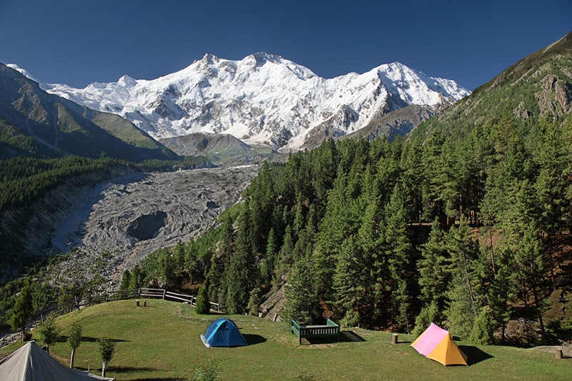
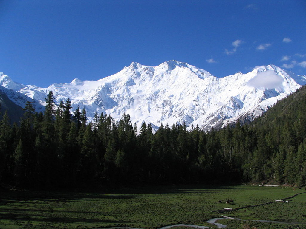
PIA flies Boeing 737s to Skardu daily (weather permitting), with views right across the Karakoram. The Islamabad to Skardu flight lasts one hour and is filled with exciting views of Nanga Parbat and Lesser Himalayas.
Overnight in Hotel.
The Indus barely seems to move across the immense, flat Skardu Valley, 40km long, 10km wide and carpeted with silvery grey sand dunes. In between dust storms, the land seems cleansed and freeze-dried, and the light is intense. The brown mountains give no hint of the white giants beyond. Skardu, at 2290m, is on a ledge at the foot of Karpochu, a rock sticking 300m out of the plain.
The town has been a mountaineers’ haunt for over 150 years, and a military headquarters since Partition, but it’s also the base for many classic Karakoram treks, and even some good day trips. Midsummer is prime mountaineering season, when jeeps and hotel space may be hard to find. Walking and trekking can be pleasant even in October when prices start to fall and the weather is clear and cold. From November to March, temperatures drop to freezing.
Sights
Satpara Lake & Buddha
Nine kilometres south of Skardu is beautiful Satpara Lake, brilliant blue and stocked with rainbow trout, but no longer pristine. A road, parts of it already paved, runs past the lake and 6km to 8km on to Satpara village. Roughly 25km beyond the village, the track crosses the Ali Malik Mar pass onto the Deosai Plains. The most popular trekking route goes from Skardu up Burji Nala, to the west of Hargisar.
Across Hargisar Nala from the track is a Buddha relief carved on a rock in about the 7th century. Near the end of this is a footbridge across the Nala, and a track up to the Buddha. There and back is a detour of about an hour.
Kachura Lake
Thirty kilometres west of Skardu, off the road to Gilgit, this small lake is known mostly for the expensive Shangri-La Tourist Resort with its ersatz Chinese architecture and a DC-3 fuselage converted into a cafe. This resort purports to be luxury, and though it has a wonderful setting and the cabins are comfortable.
There are petroglyphs along the streamside trail up Shigarthang Lungma (lung is Balti for a tributary valley), above the lake. This is an alternative to Satpara Lake for trekking the Deosai Plains (Kachura to Astor in four to six days).
Overnight in Hotel.
On the roadside west of Gol, an attractive oasis of wheat terraces and fruit trees about 35km from Skardu, are boulders carved with Buddhist motifs, old script and modern graffiti. Half an hour on, the road crosses the Indus and joins the Shyok. The opposite is Keris, at the mouth of a valley that was once a separate kingdom under a branch of Khaplu’s royal line.
Ancient Khaplu starts past the bridge at Ghowari, first of a series of prosperous-looking villages strung like pennants along with a harsh and rather overpowering setting. Near Karphok the road is carved into perpendicular walls. Twenty minutes on, huge Thalle Lungma gives a glimpse of the Masherbrum Range; up this valley is a three- or four-day trek from Khasumik over the 4572m Thalle La to Shigar.
From Khaplu village, it’s still 70km to 80km up the Shyok to the Line of control, but the road is closed to foreigners and you are unlikely to get past the police checkpoint at Khaplu even if you are just headed to the village of Surmo for a view of Masherbrum.
From Khalpu the road crosses the Skyok, and turn into a dirt track which we will follow to Hushe. The terrain is only accessible by small 4×4 wheels. After three-four hours we will reach Hushe, our camp for the night.
Overnight in Camps.
Two hours. A scenic, flat and easy hike to the best place to camp the first night, if you set off early in the afternoon. Cross the footbridge in Hushe to the west bank and walk for 20 minutes through fields of barley, peas and potatoes (in August) to a footbridge by a mill across the Honboro River—an optional side trip. The marshy area beyond the fields leads to scrubland covered with wild roses, willows, juniper and thorn bushes, followed by a large settlement of stone huts with a mosque that is used by the shepherds as soon as the snows melt in April or May. By early July, the higher pastures are usually clear, and the shepherds move further up.
Beyond the settlement, a footbridge crosses the Aling River and leads to Dumsang, a good stopping place under willows and beside a stream, about 90 minutes from Hushe. From Dumsang you can see the meeting of three valleys: the Aling coming in from the west, the Gondoghoro from the east and the Masherbrum from the north. A further 30 minutes’ easy walk brings you to Parbisan, the traditional first camp and pay stage, which is only about six kilometres from Hushe. This is a beautiful spot on the edge of a tamarisk wood.
Overnight in Camps.
three to four hours. The trek starts through dense tamarisk jungle that is marshy underfoot, beyond which the terrain changes to difficult glacial moraine—a gravelly expanse of sliding boulders at the snout of Masherbrum Glacier. Follow the stream up, keeping it on your right, to about 200 metres before it comes out of the glacier snout, where a gully comes down from the left. Cross the snowdrift at the bottom of the gully, and follow the almost vertical, ill-defined path up the right (north) side of the gully, which goes straight to the top of the western lateral moraine of the Masherbrum Glacier—a one-hour climb. You will need a guide to point out the way, and there may be a gentler path up the moraine from the end of the tamarisk wood. In August the top of the moraine is a sea of purple vetch, with clumps of Columbine, potential, rockroses and willow bushes. The walk along the top of the moraine, still climbing, is the prettiest of the whole trek. You wade through flowers with superb views on your right over the Masherbrum Glacier, south to craggy spires and sheer cliff faces, and north to Masherbrum Peak.
Brumbrammah (meaning ‘between mountain and willow bush’) campsite is down to the left of the lateral moraine below the mountain wall, on a wide, flat, sandy area surrounded by willow bushes, Edelweiss and many other flowers. This is a lake in July, but the water supply dries up in mid-August. Joining the main valley here is Bruni Brama, a side valley leading up to Cathedral, Mitre, Sceptre and Crown peaks.
Overnight in camps.
two to four hours. Two paths lead north, one along the base of the mountain in the ablation valley, and the other along the crest of the moraine, to Choosing (meaning ‘big grassy place’), 30 minutes away. Here in the square, flat-roofed stone huts about five women spend the summer looking after about 1,000 sheep and goats and an equal number of yaks and cows (including the various crosses between the two: Yakumo, dzomo and do). The mountainside above the settlement is green and crisscrossed with animal paths—a friendly place to camp if you are not in a hurry. The porters’ feast and singsong in the evening.
The path climbs from the settlement up the lateral moraine, then follows the top for a few minutes before dropping onto the edge of the glacier and losing itself amid the boulders. Your guide will show the way for one hour to Masherbrum Base Camp, at about 4,200 metres, a small grassy patch below the cliff face, looking across the glacier at the fluted ice gullies and steep rock ridges of Masherbrum. This is the top of the valley, a dead end in a wide bowl completely filled with the glacier. Ice faces soar out of deep crevasses, sheer rock walls enclose the bowl, and certain of 7,000-metre peaks prevents access to the Baltoro Glacier beyond.
In July there is a clear, ice lake just above the base camp. A two-hour walk on the lateral moraine towards Masherbrum leads to another campsite strewn with flowers. Climbers can make an attempt on the ridge above the base camp for excellent views across to Masherbrum.
Overnight in Camps.
The day is reserved for you to explore your surroundings. You may relax, sunbath or read a book to spend your time.
Overnight in Camps.
Four to five hours. We will cover one and a half stage back to Hushe today. Since we are going down walk and height won’t be the problem.
Overnight in Camps.
Three hours.Today we will enter Hushe. A isolated village in Khaplu valley totally dependent on tourism for its survival throughout the year.
Once we arrive in Hushe we will climb our waiting vehicles to Skardu.
Overnight in Hotel
Today we will start another exciting journey from skardu to chilas.
After crossing the Ayub bridge you will enter Basho, the canyon closes we travel towards Chilas. About 2 hours from Skardu is the regional centre Thowar. Across the river is Mendi, capital of the ancient Rondu kingdom.
With its size, desolation and the nonstop foaming fury of the Indus, the gorge from here south is simply awesome. Where there are no bridges, people still cross by pulling themselves hand over hand in a sphincter-puckering contraption consisting of a platform hung from a pulley on a single cable, often hundreds of metres above the river. At the truck stop of Thangus, 53km from the KKH, look across the river for miners scraping out a living by burrowing into the mountain’s quartz veins for crystals.
After 172km and 38 km south of Gilgit, the road to Skardu joins the KKH and after crosses a bridge and a spit of rock into the upper Indus Valley. Ten minutes before the bridge is a perfect panorama of the entire Nanga Parbat massif, and shortly afterwards there’s a brief view ahead to Rakaposhi’s south face. Fifteen minutes later the Indus joins Gilgit river and here is the place where three mighty ranges of Himalaya, Karakorum and Hindukush meet. There is monument at this site as well. we will continue on KKH to chilas which is five hours drive from this monument.
Overnight in Hotel
We will continue to travel on KKH towards Islamabad or we can take Babusar top route towards Naran(4×4 vehicle only) which is much cooler and greener than Karakorum Highway once on top you can have unparalleled views of Nanga Parbat from 4200m top.
Overnight in Hotel
After an amazing Karakorum experience you will transferred to airport for onward destination.
| Dates | Adult Price | Deposit | Status | More Info | |
|---|---|---|---|---|---|
| 2026 | |||||
| 20-Jul to 01-Aug | US$1,800 | US$250 | Open | Book Now | |
| 03-Aug to 15-Aug | US$1,800 | US$250 | Open | Book Now | |
| 17-Aug to 29-Aug | US$1,800 | US$250 | Open | Book Now | |
| 31-Aug to 12-Sep | US$1,800 | US$250 | Open | Book Now | |
| 14-Sep to 26-Sep | US$1,800 | US$250 | Open | Book Now | |
| 2027 | |||||
| 06-Jun to 18-Jun | US$1,800 | US$250 | Open | Book Now | |
| 20-Jun to 02-Jul | US$1,800 | US$250 | Open | Book Now | |
| 04-Jul to 16-Jul | US$1,800 | US$250 | Open | Book Now | |
| 18-Jul to 30-Jul | US$1,800 | US$250 | Open | Book Now | |
| 01-Aug to 13-Aug | US$1,800 | US$250 | Open | Book Now | |
| 15-Aug to 27-Aug | US$1,800 | US$250 | Open | Book Now | |
| 29-Aug to 10-Sep | US$1,800 | US$250 | Open | Book Now | |
| 12-Sep to 24-Sep | US$1,800 | US$250 | Open | Book Now |