Introduction
We start our trip from Peshawar, the capital of North West Frontier Province, is our kick off point for the trip. From here we travel overland, over 3,200 meters Lowari Pass. We visit the Kafir Kalash, a tribe living in isolated Hindokush who trace their origin to the lost warriors of Alexander The Great.
From here we start our 14 days trek through the rocky Hindokush landscape, over the four Passes to descend in lake-filled alpine green wonders of Gilgit
We use soft top 4×4 jeeps to explore the remote valleys of the three highest mountain ranges of the world: Hindukush, Karakoram & Himalayas. As our jeeps take us deep into valleys, we even leave the jeeps to walk through the mountains to feel their grandeur.
We start our trip from Chitral Valley and finish it in Gilgit, the administrative capital of northern areas of Pakistan. In this trip we walk beside the famous historical Wakhan corridor & crossing Zani, Shah Jinali, Broghil Passes & Koramabar Passes.
Islamabad International Airport(Google Map)https://goo.gl/maps/XLSCs8vW7NpdQp8t7
3 Hours Before Flight Time
Meet & assist on arrival at Islamabad airport, freshen up at a hotel & then drive to Peshawar. Traveling on the Grand Trunk Road laid down by the Pathan Emperor of United Indian Empire: Sher Shah Suri. Crossing Indus river at Attock, we may stop for photo at the meeting point of Indus & Kabul rivers just beyond Attock bridge. Arrive Peshawar and visit the most important and strategic land route leading to Indian sub-continent. All the historic invaders, including Alexander The Macedonian, had used this route to explore the wonders of fertile land that lies south of this pass. We may be allowed to visit Michni Post from where we have a panoramic view of the Pak-Afghan border. (45 km one way) Afternoon city tour. Peshawar has always been important in the history of sub-continent because of its location by Khyber Pass & Gandhara civilization. Overnight at Hotel (170 km, 3/4 Hours)
Breakfast at hotel, proceed for the fabled valley of Chitral by road. Passing through the lush green plains of Peshawar, we ascend the Malakand Pass that brings us to the Swat valley. We drive shortly through the Swat valley to arrive at the village of Dir for lunch. From Dir, we leave the asphalt road and drive on jeep track to ascend of Lowari Pass (3,200 Meters), the gateway of Chitral Valley. From the top of the pass, we have a fascinating view of the Hindukush mountains stretched towards North in front of us, and Himalayan mountains in the south. The descent of the pass is more interesting than the ascent, as we take 96 hair-pin turns to get to the valley floor. Passing through the dry and rocky landscape we arrive at Chitral town. Overnight Motel.
Two hours jeep drive from Chitral to Buni. Buni is the largest town in upper Chitral, and quiet historic place because of the siege of Chitral in 1895. Buni town is on the south of Mastuj river. Othal is a bit further settlement after Buni if the road remains open then the jeeps go up to Othal. We will start walking from Othal a zigzag path leads to Zani Pass. Views from the top of Zani Pass are outstanding. Top of Zani Pass is wide flat ground with outstanding views of Trich Mir (7708meters) the highest peak of Hindukush range and also the Trich valley on our west. In the north, the pass offers views of Wakhan corridor and Afghan border. On our east will be the area of Shah Jinali and Broghil Passes and in South will be the main Chitral town. After some photography on the top, we will descend down on the Trich valley side of the Pass and walk towards Zundragram our first camping site. Overnight at camps.
Today we will continue our trek in Trich valley the trek today is easier than yesterday. We will walk along the Rich river, half of the distance will be covered by jeeps today. arrive Sor Rich for overnight camping.
This is a beautiful walk through knee-high grass and flowers and across plenty of side streams surrounded by groves of willows, with the Shah Jinali river well below you on your left. After three hours the path turns north and here we will leave the mainstream and climb up a green hillside. Arrive Jinali Ghari a summer shepherds settlement.
Today in the start the trek is again through the knee-high geraniums and wild onions, with good views north to the snowy dome of Qalaeast (6315meters) and a mountain wall separating you from Afghanistan and the Oxus river. Just before the top is a wide flat meadow which is known as the “Kings Polo Ground” that gives the pass its name Shah Jinali. We will cross the meadow and arrive at the top of the Pass. The top is also flat, with several small lakes on either side. We will walk down to Yashkist for overnight camping.
On the trek, we would encounter many river crossings, so it is wise to keep sneakers in your day pack. For the first 3 hours, we walk under the shade of poplar and willow trees along the bank of Yarkhun river, crossing three branches of Kankhun river (no bridges). Excellent views of Thui peaks with their respective glaciers: Thui II (6,525m) with Shetor glacier, Thui I (6665m) in the middle of Panarello glacier & Kotalkash glacier and Kouo Zom (6875m). We camp at (3325m) on a green spot facing the Kouyo Zom mountain in the south, Broghil region begins from here and local people have Mongolian features, having migrated from Wakhan.
Today we are in the area called Boroghil, that offers the easiest route between Indian sub-continent and Central Asia, frequently featuring in the history. The population speaks Wakhi language, also spoken in southern Tajikistan, eastern Sinkinang and upper Hunza (Pakistan). We ascend around a thousand feet from the river to a vantage point with excellent views of Chhatibol glacier with its numerous crevasses. Ishkarwaz houses Chitral Scouts and border police`s post to guard the entrance to Wakhan Corridor through Boroghil Pass. Wakhan Corridor is 15 km wide belt of Afghanistan separating Pak. and Tajikistan. While finalizing the boundaries between Afghanistan and British India, this belt was purposely planned as buffer zone between British India and the Russian Empire.
Broghil Pass was used to be the shortest and easiest route from Central Asia to the Indian Subcontinent. These days it not allowed to cross Broghil Pass we will only go to the top of the pass and walk back by the same route to Ishkarwarz for overnight camping. On our way to the Broghil Pass, we will leave our packs in Ishkarwarz our tonight’s camping site and carry only water and cameras with us.
From Ishkarwaqz three main treks divert in different directions. We take the eastern option, a leisurely walk along the Yarkhun river passing by horses and Yaks grazing on green pastures. As we pass the northern trek leading over 3888m Darwaza Pass (meaning Door in Urdu ) to Wakhan. We arrive at summer settlement of Lashkargaz (meaning cavalry’s pastures) home of the Sardar (chief) of Bjoroghil. Three hours walk further is Lalay Rabat at 4000 m. Today the trek is flatter and we will walk along the Yarkhun river through many green meadows.
Unlike many trek days in Pakistan when the day over the pass is the hardest, this is a lovely day. Passing through rolling pastures and romantic Karambur Lake we arrive at the flat top of Karambur Pass with pools draining in lakes on easy and west sides of the pass. As we descend down gradually through broad green valley and lovely Zhoe Lake which is scattered in miles, we leave behind North West Frontier Province and enter in the Northern Areas. Camp at Shuinj.
Walking along the left bank of Karambur river for two hours we arrive at the snout of Cashbox glacier and then cross the glacier to the south side of the valley that is completely filled at this point by the glacier. We continue our trek along its edge for about three hours to arrive at our campsite at 3353 m surrounded by birch and willow bushes.
Easy, flat walk of eight kilometres along the south bank of Karambit river. Arrive Chilinji at 3201 m, a sandy patch at the base of Chilinji Pass.
The trek is not strenuous anymore and today we will walk along the Chilinji river. Arrive Yasin the most beautiful camping site of our trek, with lots of trees and green pastures.
Matramdas is the first permanent settlement after crossing Koramabar Pass. The place is consists of about ten house, beside the Chilinji river. It is a wide flat area and people are very friendly. enjoy another walking day.
If the road remains open then the jeeps reach to Bilhinz. Today we will walk in Ishkoman valley. In our east will be the Gilgit area across Naltar Pass and in our west across Ishkoman and Korambar Passes will be the Chitral valley. Today’s trek is quite soft. Arrive Bilhinz and small village consists of about 20 houses. Arrive and camp overnight.
Today we will board on 4×4 soft top jeeps or we will take a short walk to road blockage area in case of any road blockage. Drive to Gahguch the biggest town in Ghizar valley. This interesting drive is along the Ghizar river. By lunchtime we will be in Gahguch for overnight camping.
Today we will drive towards Gilgit the administrative capital of Northern Areas of Pakistan. Arrive Gilgit and transfer to hotel for fresh-ups. After lunch we drive out from Gilgit to re-enter the town from the historic route, crossing a suspension bridge over the river. At Kargah to visit the rock-carved Buddha from 7th century AD. In ancient times, the Kargah valley used to be the travelling route of the Buddhist monks, to go to Taxila. Stroll down the colourful Bazaars of Gilgit. Overnight in hotel.
Day 18 – Drive to Besham Now we are on the Karakoram Highway
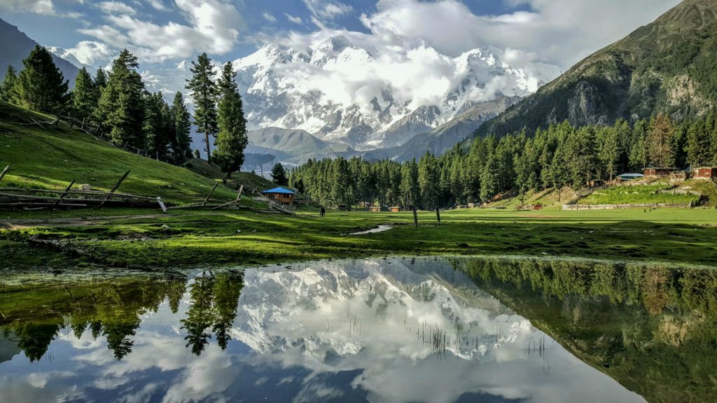
Now we are on the Karakoram Highway, on the bank of Indus river. We enter the narrow rocky gorge of Indus. The Highway was a joint venture between Pakistan and Chinese army engineers and it took 20 years & 850 lives to complete this 8th wonder of the world. After three hours drive, we will stop in Jaglot a unique place of its kind in the world. Here the worlds three highest mountain ranges Himalayas, Karakorams and Hindukush are meeting it is also the meeting point of Indus river with Gilgit river. We also have fascinating views of Nanga Parbat (8,125 M) from here. After a lunch break in Chilas, we will continue our drive to Besham. By evening we will arrive Besham. Overnight at the hotel.
Drive on the greener part of KKH to Islamabad. We may stop at Taxila, the archaeological site of Gandhara Buddhist civilization dating from 500 BC to 500 AD era. At Islamabad, transfer to hotel for overnight.
We also have the time to hunt the colourful bazaars. Farewell dinner at a traditional restaurant, overnight at hotel.
Transfer to airport for international departure flight